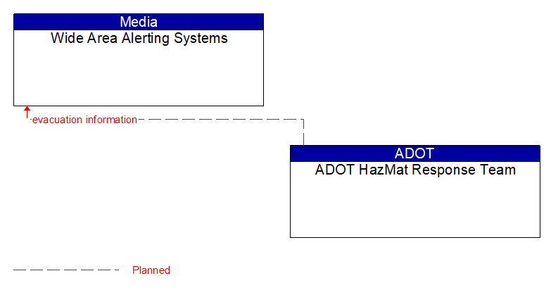
Interface: Wide Area Alerting Systems - DEMA CRT - HazMat Response Team

Wide Area Alerting Systems to DEMA CRT - HazMat Response Team Interface Diagram

Architecture Flow Definitions

alerts and advisories  (Planned)  Applicable ITS Standards

Assessments (general incident and vulnerability awareness information), advisories (identification of threats or recommendations to increase preparedness levels), and alerts (information on imminent or in-progress emergencies). This flow also provides supporting descriptive detail on incidents, threats, and vulnerabilities to increase preparedness and support effective response to threats against the surface transportation system.

evacuation information  (Planned)  Applicable ITS Standards

Evacuation instructions and information including evacuation zones, evacuation times, and reentry times.

incident information  (Planned)  Applicable ITS Standards

Notification of existence of incident and expected severity, location, time and nature of incident. As additional information is gathered and the incident evolves, updated incident information is provided. Incidents include any event that impacts transportation system operation ranging from routine incidents (e.g., disabled vehicle at the side of the road) through large-scale natural or human-caused disasters that involve loss of life, injuries, extensive property damage, and multi-jurisdictional response. This also includes special events, closures, and other planned events that may impact the transportation system.

road network conditions  (Planned)  Applicable ITS Standards

Current and forecasted traffic information, road and weather conditions, and other road network status. Either raw data, processed data, or some combination of both may be provided by this flow. Information on diversions and alternate routes, closures, and special traffic restrictions (lane/shoulder use, weight restrictions, width restrictions, HOV requirements) in effect is included.

traffic control information  (Planned)  Applicable ITS Standards

Represents the flow of traffic control and status information from a TMC to a third party TIC. This is reporting only, not actual control.

traffic images  (Planned)  Applicable ITS Standards

High fidelity, real-time traffic images suitable for surveillance monitoring by the operator or for use in machine vision applications. This flow includes the images and meta data that describes the images.

transportation system status  (Planned)  Applicable ITS Standards

Current status and condition of transportation infrastructure (e.g., tunnels, bridges, interchanges, TMC offices, maintenance facilities). In case of disaster or major incident, this flow provides an assessment of damage sustained by the surface transportation system including location and extent of the damage, estimate of remaining capacity and necessary restrictions, and time frame for repair and recovery.